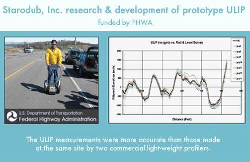
ULIP is a Segway based sensor and acquisition system for
collecting pavement surface data for the computation of ride quality, surface
texture, and other surface features. Two recent variants of the ULIP are ULIPs
(Sidewalks) and ULIPr (RoLine sensor for 3D pavement surface texture
measurements.)
ULIPs -- Ultra-Light Inertial Profiler for Sidewalks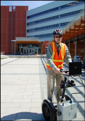
The Americans with Disabilities Act Application Guidelines (ADAAG) defines what is considered to be accessible curb ramps, sidewalks, and ramps. Sidewalk and sidewalk ramp guidelines address cross slope limits and running slope (grade) limits over a specified run length. Guidelines also provide limits and treatments for sidewalk vertical changes (bumps). Local jurisdictions need to assess their sidewalk system relative to ADAAG. Starodub, Inc. developed a prototype ULIPs system for the Federal Highway Administration. The ULIPs variant of ULIP was designed to cost-effectively measure sidewalk cross slope, running slope (grade), and bumps (and bump treatments), and to output ArcInfo compatible data for inclusion with a GIS system of local governments for easy display and analysis of the collected and processed data. A case study evaluation was carried out in Bellevue, WA. Franz Lowenherz of the City of Bellevue, WA (pictured here) was the case study field manager.
In June 2013, Starodub, Inc. and Cole and Associates signed an exclusivity and licensing fee agreement (Agreement). Starodub developed the Ultra-Light Inertial Profiler (ULIP) technology to collect measurements and data to determine compliance with the Americans with Disabilities Act (ADA) Accessibility Standards (identified later herein as ULIP-ADA technology). The terms ULIP and ULIP-ADA are trademarked, and the data collection and data processing software of the ULIP-ADA technology enjoy copyright protection.
COLE provides professional and consulting services to public and private entities for compliance with applicable State and Federal accessibility laws, regulations and various construction-related codes at the Federal, State, and Local levels. These services include measurement and data compilation with information retrieval functions that can be performed by the ULIP-ADA technology and associated software system.
COLE obtained exclusive use of the ULIP-ADA technology and associated software system to provide it with a competitive advantage in offering professional services to its clients. Starodub and COLE entered into this Agreement to provide an exclusive relationship between the parties relating to the ULIP-ADA technology and associated software system use and the revenues generated by that use.
The Agreement pertains to the application of ULIP-ADA technology to ADA measurement-data collection related projects, including but not limited to any ADA Accessibility Guidelines compliance measurement of running grade, cross slope, and bumps (also known as faults, heaves, elevation changes) or path obstructions and pavement condition. In this Agreement, Starodub agrees to grant COLE the exclusive nationwide right to use the ULIP-ADA technology and associated software system for professional and consulting services provided to their clients and provide them with two ULIP-ADA version 2 units on demand equipped with the ULIP-ADA technology and associated software system suitable for use by COLE. Starodub will further provide maintenance and repair services with respect to the units supplied to COLE. All ULIP-ADA units remain the property of Starodub. For information on ADA compliance services using ULIP-ADA version 2014, please go to Cole and Associates, Inc.
The following
Acrobat PDF files are available:
![]() ULIPs_Bellevue_WA_WSDOT
Presentation on ADA Inventory 7-31-08.pdf
ULIPs_Bellevue_WA_WSDOT
Presentation on ADA Inventory 7-31-08.pdf
![]() ULIPs_Bellevue_WA_ada_report_summary0708.pdf
ULIPs_Bellevue_WA_ada_report_summary0708.pdf
The Bellevue, WA. final report on the assessment of
sidewalks will be available as a PDF file in June, 2009.
A ULIPs validation report is also available:
![]() ULIPs_Bellevue_WA_validation.PDF
ULIPs_Bellevue_WA_validation.PDF
To see a presentation by Franz Loewenherz from the City of Bellevue, WA, at a Portland State University class seminar, click on either of the following links. Move the time slider up 8 minutes (Time 8:00) to the begining of the presentation. The presentation is about an hour long.
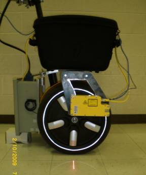
ULIPr -- Ultra-Light Inertial Profiler for 3DTexture Measurements
The ULIPr version of the Ultra-Light Inertial Profiler is designed to capture a three-dimensional representation of the travel surface (approximately 100 mm wide) at a resolution sufficient for three-dimensional texture and feature analysis. The r in ULIPr is for the RoLine 1130 laser line scan sensor used to acquire the travel surface information.The RoLine Sensor is the yellow object with the laser line visible on the floor.
More detailed information is
available as a PDF file:
![]() ULIPr.pdf
ULIPr.pdf